Google Mapping and API charging is a critical consideration for developers leveraging location services. Understanding the pricing models, usage metrics, and optimization strategies is essential for avoiding unexpected costs. This comprehensive guide explores the nuances of Google Maps Platform APIs, from introductory explanations to advanced usage concepts, ultimately empowering developers to make informed decisions.
This in-depth exploration delves into the different types of APIs available, including Directions API, Places API, and more. We’ll analyze pricing tiers, usage limits, and effective strategies for cost optimization, including examples and real-world scenarios. The discussion will also touch on alternatives to Google Maps APIs, providing a broader perspective on available options.
Introduction to Google Maps Platform APIs
The Google Maps Platform offers a suite of APIs that allow developers to integrate powerful mapping functionalities into their applications. These APIs provide access to Google’s vast geographic data and mapping services, enabling a wide range of applications, from simple location displays to complex navigation systems. This detailed overview explores the various APIs, their functionalities, and pricing models.These APIs are crucial for building location-aware applications, offering precise geographic data, interactive maps, and seamless navigation features.
The comprehensive nature of the APIs empowers developers to create applications that integrate seamlessly with user locations, routes, and points of interest.
Types of Google Maps Platform APIs
The Google Maps Platform offers a variety of APIs, each catering to specific development needs. These APIs cover a spectrum of functionalities, from simple map displays to complex navigation and search capabilities.
- Directions API: This API facilitates the calculation of routes between specified locations. It supports various transportation modes (driving, walking, cycling, transit) and allows developers to customize route options, including avoiding tolls or highways. It is particularly useful for navigation apps, ride-sharing services, and delivery platforms.
- Places API: This API enables developers to search for and retrieve information about places of interest, including restaurants, hotels, and landmarks. It allows users to perform location-based searches, filtering by specific criteria like price range or type of cuisine. This API is essential for applications that need to provide relevant information about places based on user location.
- Geocoding API: This API converts addresses or geographic coordinates into each other. It facilitates precise location identification and is essential for applications that require precise geographic data, such as mapping applications, delivery services, and location-based games.
- Maps JavaScript API: This API allows developers to embed interactive maps directly into web pages. It provides a comprehensive set of tools for customizing map displays, adding markers, drawing shapes, and integrating other Google Maps features. It is fundamental for building interactive web applications that require dynamic map integration.
- Elevation API: This API allows developers to retrieve elevation data for specific locations. It is useful for applications that need to visualize elevation profiles or determine the terrain characteristics along a given route. It is particularly relevant to applications that require elevation data, such as outdoor activities or route planning applications.
Core Functionalities of Each API
Each API within the Google Maps Platform provides a unique set of functionalities. Understanding these functionalities is key to selecting the appropriate API for a given application.
- Directions API: Calculates optimized routes, handles multiple transportation modes, provides real-time traffic data, and allows customization options like avoiding tolls.
- Places API: Provides comprehensive information about places, including ratings, reviews, photos, and opening hours. It enables location-based searches and filtering, enabling developers to curate location-specific results.
- Geocoding API: Transforms addresses into geographic coordinates and vice-versa, enabling applications to work with location data in different formats. This is a fundamental API for location-based applications.
- Maps JavaScript API: Offers a dynamic mapping experience on web pages. This API allows for the integration of markers, shapes, and other map elements, enabling users to visualize and interact with geographic data on web pages.
- Elevation API: Provides elevation data at specific points along a given route or area, enabling applications to visualize terrain features and calculate elevation differences.
Benefits of Using Google Maps APIs
Leveraging Google Maps APIs offers several significant advantages. The integration of these APIs streamlines development and allows developers to focus on application logic.
- Accuracy and Reliability: Google Maps maintains extensive and accurate geographic data, providing reliable results for location-based applications.
- Ease of Use: The well-documented APIs and comprehensive resources facilitate easy integration and development.
- Extensive Functionality: The APIs offer a wide range of functionalities, allowing developers to create diverse and feature-rich applications.
- Widely Used: The APIs are commonly used and supported by a large community, providing ample resources and support.
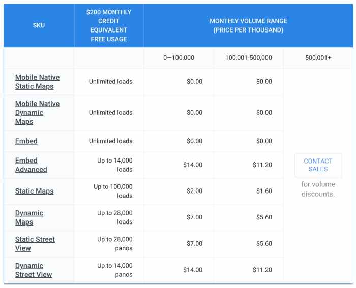
Pricing Structure
The pricing structure for Google Maps APIs varies depending on the API and usage. Generally, usage is billed based on requests. A tiered pricing system is common, providing different pricing models depending on the volume of usage.
| API | Pricing Model | Factors Affecting Cost |
|---|---|---|
| Directions API | Usage-based | Number of requests, data volume, traffic conditions |
| Places API | Usage-based | Number of requests, data volume, query complexity |
| Geocoding API | Usage-based | Number of requests, data volume |
| Maps JavaScript API | Usage-based | Number of requests, data volume, query complexity |
| Elevation API | Usage-based | Number of requests, data volume |
Pricing details are subject to change. Refer to the official Google Maps Platform documentation for the most up-to-date pricing information.
Google Maps API Pricing Models
Navigating the world of location services often involves understanding the financial aspects of using Google Maps APIs. This section delves into the various pricing tiers and factors influencing costs, offering a practical overview of how different API usage levels translate into different pricing models. Understanding these models is crucial for budgeting and planning projects that leverage Google Maps functionality.Google Maps Platform offers different pricing models tailored to various needs, ranging from simple map integration to complex location-based applications.
These models take into account the specific API used, the volume of requests, and the nature of the data utilized.
Pricing Tiers for Google Maps APIs
Google Maps Platform APIs are structured with different pricing tiers to cater to various project needs and usage levels. These tiers reflect the increasing complexity and data demands of the application. Different API types have different cost structures, influencing the total cost.
Factors Influencing Pricing
Several factors contribute to the cost of using Google Maps APIs. The primary factor is API usage, which is measured in requests. Higher usage levels naturally lead to higher costs. The location data involved is another key component. Data requests for specific locations or broader areas affect pricing.
Additional factors, such as the type of API and the features used, contribute to the overall cost.
Comparison of Pricing Models for Different API Types
Different Google Maps APIs have varying pricing structures. For instance, the Directions API, used for route calculations, may have different pricing tiers based on the number of directions requests. The Geocoding API, which converts addresses to coordinates, has pricing based on the number of geocoding requests. The Maps SDK for Android and iOS has pricing that takes into account the number of map displays and other related actions.
Understanding these nuances is essential to select the appropriate API for your project and budget.
Figuring out Google Maps API charges can be tricky, especially when you’re considering different product design approaches. Understanding the nuances between product designers and UX designers, as explored in this helpful article on product designer vs ux designer unraveling the differences , is crucial for optimizing your mapping projects. Ultimately, a strong grasp of both design roles will help you manage costs effectively and create a smooth user experience with Google Maps.
Pricing Models Based on API Usage Levels
| API Usage Level | Pricing Model | Description |
|---|---|---|
| Low | Pay-as-you-go | Ideal for basic map integrations, few requests. A flexible and cost-effective option for small-scale projects. |
| Medium | Usage-based tiered pricing | Suitable for applications with moderate usage. Offers flexibility by allowing customization based on the level of usage and features. |
| High | Custom pricing | For applications requiring extensive usage, such as large-scale location services, or real-time mapping. Provides tailored solutions for specific needs and volume. |
Pricing Examples for Specific Usage Scenarios
| Usage Scenario | Estimated Cost (USD) | Justification |
|---|---|---|
| Basic map display on a website with minimal user interaction. | $10-50 per month | Low usage level, limited requests, and straightforward features. |
| Mobile application with real-time location tracking for hundreds of users. | $500-$1000+ per month | High usage level, multiple requests, and complex functionality. Cost depends on the frequency of updates and the number of users. |
| Large-scale logistics platform providing optimized delivery routes for thousands of shipments daily. | $10,000+ per month | Extremely high usage level, extensive data processing, and advanced route optimization features. |
Understanding API Charging Metrics
Navigating the world of Google Maps Platform APIs often involves understanding how usage is measured and priced. This section dives deep into the various units of measurement, calculation examples, usage limits, and the consequences of exceeding them. Understanding these metrics is crucial for effectively managing your budget and avoiding unexpected costs.API usage isn’t a one-size-fits-all affair. Different APIs have different pricing structures, and it’s essential to grasp the specifics for each API you’re using.
This includes the various units of measurement, how they’re calculated, and the specific usage limits you’re subject to.
Units of Measurement for API Usage
The Google Maps Platform APIs use various units to track your usage. These units are designed to accurately reflect the resources consumed by your applications. Common units include requests, bytes, and storage. Understanding these metrics is key to interpreting your API bills.
Calculation Examples for API Usage
The calculation of API usage metrics depends on the specific API being used. For example, a request to the Geocoding API might be counted as one request. Similarly, retrieving a large map image might be measured in bytes, reflecting the size of the data downloaded.
API Usage Limits
Google Maps Platform APIs impose daily and monthly usage limits. These limits help manage resource allocation and ensure fair access for all users. Exceeding these limits can trigger different responses, depending on the API.
- Daily Limits: Many APIs have daily usage limits. These limits are designed to prevent overwhelming the servers and ensure smooth operation for all users. For instance, a daily limit of 100,000 requests for the Directions API would prevent a single application from consuming disproportionate resources.
- Monthly Limits: Monthly limits provide a broader perspective on usage, allowing you to plan for your application’s needs over a longer period. A monthly limit of 1 million requests might be appropriate for an application with high, but predictable, usage patterns.
Impact of Exceeding Usage Limits
Exceeding API usage limits can result in various consequences, ranging from temporary throttling to account suspension. This can significantly affect your application’s functionality, depending on the specific API and the nature of the violation. Understanding these implications is essential for proactive cost management.
Monitoring API Usage
Monitoring API usage is crucial for preventing unexpected costs and ensuring your application remains within budget. Google Maps Platform provides tools to track your usage and identify potential overages. This allows you to take corrective actions before incurring substantial charges. Utilizing these tools is an effective preventative measure against unexpected costs.
Cost Optimization Strategies
Optimizing Google Maps Platform API costs is crucial for sustainable projects and budgets. Understanding the pricing models and leveraging efficient strategies can significantly reduce expenses without sacrificing the desired functionality. This section dives into effective techniques for minimizing API costs, ensuring optimal performance and resource management.Minimizing API costs is achieved through meticulous planning and implementation of cost-saving techniques. These techniques focus on optimizing API calls, reducing unnecessary requests, and employing batching strategies.
By implementing these strategies, developers can achieve substantial savings without compromising the core functionality of their applications.
Optimizing API Calls
Efficient API call optimization is key to reducing costs. Identifying and eliminating redundant or inefficient calls is paramount. A thorough understanding of the API’s capabilities and the application’s specific needs allows for tailored requests, minimizing unnecessary data retrieval. For instance, requesting only the necessary information instead of retrieving a large dataset that contains extraneous details can lead to substantial savings.
Reducing Unnecessary API Requests
Unnecessary API requests represent a significant portion of potential cost savings. Careful consideration of the application’s logic and data flow can often reveal opportunities for reducing redundant calls. Caching frequently accessed data, pre-calculating values where possible, and utilizing local storage for static or frequently accessed information are essential strategies to mitigate unnecessary requests. This reduces the frequency of calls to the API, leading to substantial cost savings.
Batching API Requests
Batching API requests allows for combining multiple requests into a single call, significantly improving efficiency and reducing costs. This method is particularly beneficial for operations involving multiple locations or numerous data points. For example, instead of making individual API calls to retrieve information for 100 different addresses, a single batch request can be sent to fetch data for all addresses simultaneously.
This significantly reduces the number of API calls and the associated costs. Batching is a powerful technique for optimizing API usage and reducing expenses.
Examples of Efficient API Usage Patterns
Several efficient API usage patterns can significantly reduce costs. One such pattern involves using the Geocoding API to pre-fetch location data for frequently accessed areas. Caching the results can eliminate redundant calls and reduce API usage. This is particularly helpful in applications where user locations are frequently queried. Another pattern involves using the Directions API to pre-calculate routes for commonly used destinations, storing the results for later use.
This reduces unnecessary requests and avoids redundant calculations.
Methods to Reduce Unnecessary API Requests
- Caching Data: Implementing caching mechanisms to store frequently accessed data locally, reducing the number of API requests.
- Data Pre-processing: Performing calculations or data transformations locally to minimize the need for API calls to external services.
- Asynchronous Operations: Employing asynchronous operations for API calls to avoid blocking the application’s main thread while waiting for responses.
- Efficient Data Structures: Choosing appropriate data structures to optimize data retrieval and reduce redundant lookups.
- Minimizing Data Volume: Only requesting the specific data needed, avoiding unnecessary or redundant data retrieval.
API Usage Examples and Scenarios
Navigating the world of Google Maps APIs can feel overwhelming, but understanding how they’re used in real-world applications makes it significantly easier. This section dives into various use cases and illustrates how different APIs contribute to diverse applications. We’ll also explore the impact of usage patterns on costs, providing practical strategies for cost optimization.Google Maps APIs are the backbone of many location-based services, powering features from simple map displays to complex route planning and real-time location tracking.
From optimizing delivery routes for logistics companies to enabling users to find nearby restaurants, the potential applications are vast. Understanding these examples will help you tailor your API usage to your specific needs and control your costs.
Real-World Application Examples
Google Maps APIs underpin a wide range of applications, from simple map displays to complex route planning and real-time location tracking. These APIs are crucial for many location-based services, enhancing user experiences and optimizing operational efficiency.
- Navigation and Route Planning: Applications like ride-sharing services (e.g., Uber, Lyft) rely heavily on the Directions API to calculate optimized routes for drivers and passengers. The cost is influenced by the frequency and complexity of route requests. More complex routes with many waypoints or real-time updates will typically incur higher costs. For example, a delivery service using the Directions API for 1000 deliveries per day, with diverse and complex route configurations, will likely incur higher costs than a smaller business with fewer, simpler deliveries.
- Place Search and Information Retrieval: Businesses offering location-based services, such as restaurant search apps, utilize the Places API to find relevant establishments based on user input. The cost is typically tied to the number of place search requests. Frequent and complex searches might lead to higher API charges. A city-wide restaurant guide app with 100,000 place searches per day would likely have a significantly higher cost than an app with only 100 searches daily.
Google Maps API charges can be a real headache, especially when you’re trying to optimize your budget. Thinking about how 301 redirects impact SEO and PPC campaigns is crucial in this context. For example, understanding how 301 redirects affect search engine rankings (good for SEO) but can negatively affect paid search results (bad for PPC) is a key part of the equation.
Ultimately, careful planning and understanding the implications of these redirects is key to keeping your Google Maps API costs under control. 301 redirects good for seo bad for ppc This knowledge directly affects your overall cost structure when building your Google Maps integrations.
- Geocoding and Reverse Geocoding: Many applications, such as real estate portals or address validation systems, use the Geocoding API to convert addresses into coordinates and vice versa. The cost depends on the volume of address lookups. A real estate website with thousands of address lookups daily will have a different cost structure compared to a smaller app with occasional lookups.
- Map Display and Customization: Web and mobile applications use the Maps JavaScript API to embed interactive maps into their platforms. Cost is often associated with the frequency of map loads and the complexity of map displays. For example, a website displaying interactive maps with extensive features for users across the globe will have different costs compared to a website with basic map displays.
Impact of Usage Patterns on API Costs
Different usage patterns significantly impact the cost of Google Maps APIs. Understanding these patterns is crucial for controlling expenses. Frequency of requests, complexity of queries, and volume of data processed all play a role in the overall cost.
- Request Frequency: The more requests made to the API, the higher the potential cost. Regular, high-volume requests, especially those involving complex computations or large datasets, will generally result in higher costs. Applications that perform numerous API calls within short intervals could incur considerable charges.
- Query Complexity: Complex queries often require more processing power and resources. APIs with extensive parameters, multiple waypoints, or real-time updates tend to be more expensive than simpler requests. For example, a route calculation with multiple stops and real-time traffic data will cost more than a basic route between two points.
- Data Volume: APIs that process large volumes of data, such as massive datasets for geocoding or extensive route planning calculations, typically lead to higher costs. The sheer amount of data handled by the API is a significant factor in determining the overall cost.
Calculating API Costs Based on Use Cases
Determining the precise cost of Google Maps APIs for specific use cases requires careful consideration of the factors mentioned above. A detailed analysis of your application’s usage patterns and API requests is necessary.
Calculating API costs involves understanding the specific API pricing model and associated metrics for each use case.
| API Use Case | Key Cost Factors | Cost Impact |
|---|---|---|
| Navigation | Frequency of route requests, route complexity | Higher costs for frequent and complex routes. |
| Place Search | Frequency of place searches, search parameters | Higher costs for frequent and complex searches. |
| Geocoding | Number of address lookups | Higher costs for a large number of lookups. |
| Map Display | Frequency of map loads, map features | Higher costs for frequent map loads and extensive features. |
Integrating API Calls into Applications
Integrating Google Maps API calls into various application types requires a methodical approach. Different languages and platforms necessitate tailored integration techniques.
- Web Applications: The Maps JavaScript API provides straightforward integration for web applications, allowing seamless embedding of interactive maps and leveraging various functionalities. Developers can integrate these calls into their web pages to provide real-time location data or user-friendly navigation.
- Mobile Applications: Mobile application integration with Google Maps APIs often involves platform-specific SDKs or libraries. Developers need to ensure appropriate authentication and error handling to manage requests efficiently and ensure smooth application performance. Mobile apps might require location permissions for accurate functionality.
Managing and Monitoring API Costs
Staying on top of Google Maps Platform API costs is crucial for budgeting and ensuring efficient use. Proactive monitoring allows you to identify potential overspending and optimize your usage patterns to minimize unnecessary charges. Understanding how to track and manage these costs directly impacts the sustainability and scalability of your projects.
Importance of Monitoring API Usage and Costs
Effective monitoring of API usage and associated costs prevents unexpected budget overruns. By tracking your API usage, you can pinpoint areas of high consumption and adjust your strategies accordingly. This proactive approach enables cost optimization and ensures your project stays within budget constraints. Identifying trends in API usage can also provide insights into user behavior and application performance.
Tools and Techniques for Tracking API Usage
Google Cloud Platform (GCP) provides robust tools for monitoring API usage. The Billing section within GCP offers detailed reports and dashboards to track API costs. These reports allow you to view usage by individual API calls, projects, or specific timeframes. Leveraging the API usage reports helps to analyze patterns and pinpoint potential cost-saving opportunities.
Methods for Generating Cost Reports
Generating cost reports is a straightforward process within GCP. You can configure custom reports that display the data relevant to your needs. For example, reports can be tailored to show costs for specific projects, time periods, or API types. These reports allow you to gain a comprehensive understanding of your spending patterns and identify areas for potential savings.
Examples of Reports Displaying API Usage Data and Costs
GCP billing reports often display data in tabular format. Columns may include API name, usage quantity, cost, and timestamps. Visualizations such as charts and graphs are also available to illustrate trends in API usage and cost over time. For instance, a bar chart could compare the cost of different API calls over a given period, allowing for immediate identification of high-usage APIs.
A line graph might visualize the cost trend for a specific project over several months.
Procedures for Optimizing API Costs Based on Usage Patterns
Identifying high-usage APIs is a key step in optimizing costs. Analyzing usage patterns and adjusting application logic to reduce redundant requests can significantly reduce API costs. For instance, caching frequently accessed data can dramatically decrease the number of API calls required, leading to cost savings. Similarly, optimizing queries and data requests to be more efficient can also reduce API costs.
Regularly reviewing and adjusting your API usage based on observed patterns is vital for cost control. A cost-saving strategy might involve shifting peak API usage to off-peak hours if your application permits it.
Alternatives to Google Maps APIs
Exploring map APIs beyond Google Maps offers developers flexibility and cost-saving opportunities. Different APIs cater to various needs, from simpler mapping overlays to advanced routing and location services. Understanding the strengths and weaknesses of these alternatives is crucial for making informed decisions.
Alternative Map APIs
Several map APIs offer viable alternatives to Google Maps, each with its own unique features and limitations. These APIs can be a cost-effective or functional replacement depending on the specific requirements of a project.
- Mapbox: Mapbox is a popular choice known for its powerful routing capabilities, especially for navigation and delivery apps. It boasts a user-friendly API and a comprehensive suite of tools, including vector tiles for efficient rendering. However, its pricing structure can be complex and potentially higher for extensive usage compared to some simpler alternatives. Mapbox is often preferred for projects that require complex mapping functionality beyond simple overlays.

- HERE Maps: HERE Technologies provides a comprehensive mapping platform with robust features for navigation, routing, and traffic information. It is well-regarded for its real-time traffic data, making it suitable for applications requiring accurate, up-to-date location intelligence. While offering advanced functionalities, HERE Maps can be more expensive than other alternatives for less demanding applications.
- OpenStreetMap: A free and open-source alternative, OpenStreetMap relies on a collaborative community for map data. This means potentially lower costs for simple projects, but data accuracy and completeness might not be as consistent as those of commercial providers. It’s a great option for projects where cost is a primary concern and the need for complex features is minimal.
- Carto: Carto offers a scalable mapping platform suitable for applications requiring a balance of flexibility and cost-effectiveness. Its API facilitates efficient data visualization and analysis. While not as feature-rich as Mapbox or HERE, it is a solid option for applications that need good visualization and spatial analysis tools.
- Microsoft Bing Maps: Microsoft’s Bing Maps API provides a strong alternative for applications needing location-based services and data integration. It offers robust mapping functionality with competitive pricing, potentially being a good fit for developers already integrated into the Microsoft ecosystem.
Pricing Models Comparison
The pricing models for alternative map APIs vary significantly from Google Maps. Factors like usage volume, features, and data access all contribute to the cost.
| API Provider | Pricing Model | Strengths | Weaknesses |
|---|---|---|---|
| Google Maps | Tiered pricing based on usage metrics (requests, data volume, etc.) | Established market leader with extensive documentation and support. | Potentially high costs for extensive usage. |
| Mapbox | Subscription-based plans with tiered pricing. | Strong routing capabilities and customization options. | Pricing can be complex and potentially more expensive for lower usage. |
| HERE Maps | Subscription-based plans with varying features. | Extensive real-time traffic data and advanced routing. | Potentially higher cost compared to other alternatives for less demanding tasks. |
| OpenStreetMap | Free and open-source, no direct pricing. | No cost for the API itself. | Data accuracy may not be as high as commercial providers; may require additional development work for complex functionalities. |
| Carto | Subscription-based plans. | Scalable and cost-effective for data visualization. | Less extensive feature set compared to some alternatives. |
| Microsoft Bing Maps | Subscription-based plans, often integrated with other Microsoft services. | Robust mapping functionality with competitive pricing. | Integration might be beneficial for developers already in the Microsoft ecosystem, otherwise, a slight learning curve. |
Functionality Details
Each alternative API provides different functionalities, impacting the potential application development.
- Routing and Navigation: Some APIs excel at routing, like Mapbox, while others focus on general mapping. OpenStreetMap might not be as strong in this area.
- Geocoding and Reverse Geocoding: Converting addresses to coordinates and vice versa are essential functionalities across all these APIs.
- Data Visualization and Analysis: APIs like Carto are tailored to this task, allowing developers to present spatial data effectively.
- Real-time Traffic Data: HERE Maps, for instance, stands out with real-time traffic data, which can be crucial for applications requiring timely information.
Examples of Usage
The choice of API depends on the specific application. A ride-sharing app might benefit from Mapbox’s routing features, while a simple location-based service might find OpenStreetMap sufficient.
- Ride-sharing app: Mapbox’s advanced routing features allow for real-time optimization of routes, reducing travel time and improving user experience.
- Location-based service: OpenStreetMap can be used for a basic location service where cost is a major factor. Simple map overlays can be implemented using OpenStreetMap.
- Real-time delivery app: HERE Maps’ real-time traffic data provides optimal delivery routes, ensuring timely delivery and better resource management.
API Usage Best Practices: Google Mapping And Api Charging

Optimizing your Google Maps API usage is crucial for cost-effectiveness and performance. Effective strategies can significantly reduce API call latency and costs, especially when dealing with large datasets or frequent requests. These best practices are designed to enhance the efficiency and reliability of your applications.Efficient use of Google Maps APIs hinges on understanding how to handle large volumes of data, minimize latency, and implement robust error handling.
This section delves into practical techniques to ensure your applications function seamlessly and within budget.
Handling Large Volumes of Data
Efficiently processing large volumes of data is essential for applications that require extensive geographic information. Techniques like batching requests and utilizing data filtering can drastically reduce API calls and associated costs.
- Batching Requests: Instead of making individual requests for each location or point, aggregate requests into larger batches. This reduces the number of API calls, improving performance and minimizing costs. For example, if you need to fetch information for 1000 locations, sending a single request with all 1000 locations is more efficient than making 1000 individual requests.
- Data Filtering: Filter data before making API calls to reduce the amount of information retrieved. Specify precise parameters to retrieve only the necessary data points. This approach minimizes the size of the data transfer and the associated costs.
- Progressive Loading: For applications that need to display large datasets, implement progressive loading. This technique loads data in manageable chunks, improving user experience while minimizing the API load in the initial stages. This ensures a faster initial response and avoids overwhelming the server.
Minimizing API Call Latency
Reducing latency in API calls is crucial for user experience and overall application performance. Techniques such as using the right API endpoint, considering geographic proximity, and leveraging caching strategies contribute to faster response times.
- Endpoint Selection: Choose the appropriate API endpoint based on the type of data you need. Selecting the correct endpoint ensures optimal performance and reduces latency.
- Geographic Proximity: When dealing with geographically dispersed data, consider using regional endpoints. This reduces latency by reducing the distance between the user and the API server.
- Caching Strategies: Implementing caching for frequently accessed data can drastically reduce latency. This is a critical component of optimizing API call performance. Caching stored results reduces the number of requests made to the Google Maps API, leading to lower latency and cost.
Caching API Responses
Caching API responses is a vital strategy for reducing latency and costs, particularly for frequently accessed data. Appropriate caching strategies can improve performance by reusing previously retrieved data.
- Server-Side Caching: Implement server-side caching to store API responses. This can be achieved using various caching mechanisms, such as memcached or Redis. Caching on the server side allows for quick retrieval of previously requested data, minimizing latency and cost.
- Client-Side Caching: Implement client-side caching to store frequently accessed data on the client-side application. This can be done using browser caching mechanisms or dedicated libraries. Caching on the client side improves user experience by reducing latency and load time.
Proper Error Handling
Error handling is essential for robust applications that interact with APIs. Implementing appropriate error handling mechanisms ensures applications can gracefully recover from API errors and maintain stability.
Google Maps API charges can be a real headache, right? It’s always a concern when you’re building something with location services. Thankfully, Microsoft is stepping up its game in the monetization space with a major AI upgrade to their platform. This new development, detailed in microsoft monetize gets a major ai upgrade , could potentially offer more affordable and flexible options for developers, which could eventually impact the pricing strategies for Google Maps APIs.
This could be a game-changer for how we use location data in the future.
- Error Detection and Logging: Implement mechanisms to detect and log API errors. This allows for identification of issues and enables effective troubleshooting.
- Retry Mechanisms: Implement retry mechanisms to handle transient API errors. This ensures that the application does not fail due to temporary issues, such as network problems or server overload.
- Error Reporting: Report API errors to users in a clear and user-friendly manner. This helps in identifying and resolving issues, enhancing user satisfaction.
Advanced API Usage Concepts
Diving deeper into Google Maps Platform APIs unlocks a world of possibilities beyond basic mapping. Advanced concepts like custom map styles and data visualization empower developers to create highly customized and informative applications. Understanding these concepts, their impact on API usage, and effective integration strategies is crucial for maximizing application functionality while minimizing costs.
Custom Map Styles
Custom map styles allow developers to tailor the visual appearance of maps to specific needs or aesthetics. This involves modifying colors, icons, and other visual elements to create a unique map experience. By adjusting the style, developers can enhance readability, highlight specific features, and align the map’s presentation with their application’s branding.
- Impact on API Usage and Costs: Custom map styles primarily affect the data returned by the API. Slight variations might not impact usage significantly. However, complex styles with numerous modifications might lead to slightly increased API calls as the API needs to transmit the style data to the client.
- Enhancing Map Application Functionality: Custom map styles improve the visual appeal of the map, allowing users to quickly identify and focus on relevant elements. This leads to improved usability and a more engaging user experience. For example, a real estate app could use custom colors to highlight available properties or a transportation app could use different markers for various transportation modes.
- Integration with Existing Applications: Integrating custom map styles involves modifying the API calls to include the desired style specifications. This is typically done via the `map_style` parameter in the API request. This parameter allows the developer to define the custom style in a JSON format. The API will then render the map based on these specifications.
- Practical Scenarios: A city planning application could use custom map styles to highlight areas under development, or a tourism app could use different colors to distinguish historical landmarks. A financial application could customize the style to highlight areas with high property values or economic activity.
Data Visualization
Data visualization on Google Maps empowers developers to overlay and present various data types directly onto the map. This enables insights into geographical trends, patterns, and distributions. Visualizing data enhances the map’s analytical capabilities and allows users to quickly grasp complex information.
- Impact on API Usage and Costs: Data visualization often involves additional API calls to retrieve and process the data to be visualized. The complexity of the visualization will influence the API calls needed. The more data points and complex charts, the higher the API usage will be.
- Enhancing Map Application Functionality: Data visualization allows the creation of interactive maps that provide insights into the spatial distribution and patterns of data. For example, a crime mapping application can overlay crime statistics onto the map, allowing users to identify high-crime areas and analyze trends.
- Integration with Existing Applications: Integrating data visualization involves retrieving data from external sources (databases, spreadsheets, etc.), formatting it to be compatible with the Google Maps API, and then using the API’s visualization features to display the data. Specific libraries and tools are available to assist with this process.
- Practical Scenarios: A real estate application could use heatmaps to display property values in different areas. A traffic monitoring app could use colored markers to indicate traffic congestion in different regions. A health care application could use a map to visually represent disease outbreaks and track their spread.
Future Trends and Developments in Google Maps APIs
The Google Maps Platform APIs are constantly evolving, driven by technological advancements and user demands. Anticipating these shifts is crucial for developers to maintain competitive edge and ensure their applications remain relevant. This section explores the potential future directions of these APIs, including anticipated changes in pricing, features, and functionalities.The future of Google Maps APIs likely involves increased integration with other Google services, such as AI and machine learning models.
This integration promises more sophisticated features and functionalities, such as real-time traffic prediction enhanced by AI analysis of massive datasets, and more accurate route optimization based on dynamic factors.
Anticipated Changes in Pricing Models
Google’s pricing models for its APIs are typically designed for scalability and cost-effectiveness. However, changes are always possible to accommodate new features and advancements. Possible adjustments may involve tiered pricing structures based on usage volume or specific functionalities, allowing developers to choose plans tailored to their needs and budgets.
Potential Feature Enhancements
Several enhancements are probable in existing APIs and the introduction of new ones. For instance, enhanced 3D mapping capabilities are likely, providing more immersive visualizations and experiences for users. Integration of augmented reality (AR) features with navigation could also be introduced.
Impact on Application Development
These future developments will significantly impact application development. Developers need to adapt to evolving functionalities, potentially modifying their existing applications to leverage new features or build entirely new applications. Understanding the evolving APIs will enable developers to incorporate these advanced functionalities into their applications, providing users with more intuitive and accurate solutions.
Potential Challenges Related to API Usage and Costs, Google mapping and api charging
Developers may face challenges related to API usage and costs as Google Maps APIs continue to evolve. The increased complexity and sophistication of features could lead to higher usage costs, particularly for applications requiring substantial data processing or real-time updates. Careful planning and cost optimization strategies will be vital to mitigate potential cost overruns. For example, real-time traffic updates may require more frequent API calls, leading to increased costs.
Effectively managing and monitoring usage is key to ensuring that costs remain within budget.
Wrap-Up
In conclusion, navigating Google Maps API charging requires a deep understanding of the pricing models, usage metrics, and optimization techniques. This guide has provided a roadmap for developers to efficiently utilize these powerful tools without incurring unnecessary costs. By considering alternatives and best practices, developers can build robust location-based applications while keeping budget considerations in mind.